Torrential rains and flooding ravage Central Europe: the worst in 70 years

Wait a minute… back in 1997, around the time of the death of Princess Diana, central and eastern Europe were experiencing “The Flood of the Century.” That’s was also the year of Comet Hale-Bopp. Connection?

Torrential rains and flooding ravage Central Europe: the worst in 70 years

Authorities in parts of Europe issued disaster warnings and scrambled to reinforce flood defenses as rivers swelled by days of heavy rain threatened to burst their banks. Several people have died or are missing in the floods in Germany, the Czech Republic, Austria, and Switzerland since the rains began on Thursday. The floods have killed at least one person and left several missing across the Czech Republic. Czech officials warned that the waters of the Vltava river could reach critical levels in Prague late on Sunday as soldiers erected metal barriers and piled up sandbags to protect Prague’s historic center from flooding after days of heavy rains swelled rivers and forced evacuations from some low-laying areas. Prague authorities also limited public transport and closed underground stations as water from the Vltava River overflowed into parts of the Old Town.

Volcanic riddle: burst in Mount Etna eruptions puzzles experts

Volcanic riddle: burst in Mount Etna eruptions puzzles experts

“The eruptions in recent weeks have been unusually fierce and explosive,” reports German volcanologist Boris Behncke… “There have been lava fountain events in the past, but rarely in such rapid succession.”

Maybe it’s clearing a path for a big blow? That’s sorta what Krakatoa did back in the day.

Monster May snow buries Newfoundland

Another snowfall record broken; global warming, eh?

Monster May snow buries Newfoundland

A record-smashing snowstorm has buried parts of Newfoundland under about 2 feet of snow.

There were no reports of serious damage or disruption.

Gander tallied a heavy, wet snowfall of 69 cm (7 inches) between Saturday morning and Sunday night, weather data accessed by AccuWeather.com showed. Of this amount, 46 cm fell (18 inches) within only 12 hours on Sunday. The snow depth reached at least 55 cm (22 inches) on Sunday and still stood at 51 cm on Monday morning.

The snowfall had a water equivalent of about 69 mm (2.7 inches), which amounts to the lion’s share of the normal May precipitation of 86 mm.

Four unique fireball events fall over U.S. in 24 hour period – wide range reported

The planet is turning into a shooting gallery and still the madness continues.

Four unique fireball events fall over U.S. in 24 hour period – wide range reported

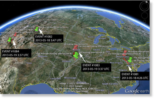
In the last 24 hours the AMS has received confirmed reports about 4 unique fireball events all occurring near 4:00 AM UTC time. The most recent event occurred in Arkansas and Missouri on May 19th near 3:37 UTC. At the same time 3:37 UTC 4 witnesses reported a fireball in Arizona. The distance between these two locations would inhibit witnesses from observing the same fireball from both locations. On May 18th two large fireball meteors were also spotted within an hour of each other, one over the central east coast and another in Colorado. –AMS

Strange weather and the Syria distraction

And all our “brilliant” leaders can do is quibble over where the next war is going to be…

All eyes on Syria: Russian warships enter Mediterranean to form permanent task force

Warships from Russia’s Pacific Fleet have entered the Mediterranean for the first time in decades. Russia’s Navy Chief says the task force may be reinforced with nuclear submarines, as the country starts building up a permanent fleet in the region.

“The task force has successfully passed through the Suez Channel and entered the Mediterranean. It is the first time in decades that Pacific Fleet warships enter this region,” the Pacific Fleet spokesman, Capt. First Rank Roman Martov told RIA.

Keeps our eyes off the weather, the fireballs, the earthquakes, coming famines, plagues, etc.

Wall of ice destroys Manitoba homes, cottages

This is May, remember. How’s that “Global Warming” working for you?

Wall of ice destroys Manitoba homes, cottages

Wall of ice destroys Manitoba homes, cottages

A local state of emergency has been declared in a western Manitoba municipality after homes in Ochre Beach were destroyed and seriously damaged by a wave of lake ice.

Area officials told CBC News the wind pushed built-up ice off Dauphin Lake on Friday evening and caused it to pile up in the community, located on the lake’s southern shore.

The piles of ice, which were more than nine metres tall in some cases, destroyed at least six homes and cottages, according to the Rural Municipality of Ochre River.

Global Cooling: Sudden European temperature plunge over the last decade… Are we on the brink of a Little Ice Age?

Global Cooling: Sudden European temperature plunge over the last decade… Are we on the brink of a Little Ice Age?

So since 2000 the CET shows an annual temperature diminution at the rate of -0.49°C/decade or -0.59°C in 12 years: this negates almost the entire CET temperature rise since 1850. Although this is a very short period, the extent of the climate change that has been observed since the turn of the millennium is remarkable. …

At ~10,500 years our current cooler but benign Holocene interglacial is coming towards its end and the reversion of our planet to a real ice age is foreseeable.

No faked hockey-sticks here! (Follow the link for the charts.)

Incredible North Atlantic storm spans Atlantic Ocean, coast to coast

Global superstorms increasing. And all the elite can do is make things worse with more oppression and war-mongering. Don’t they get it that it is the collective consciousness of the unhappy masses and the ravaged planet? That they, too, will die when the body they are infecting is destroyed by their rapaciousness?

Incredible North Atlantic storm spans Atlantic Ocean, coast to coast

I’m not sure I’ve ever seen a storm this big before.

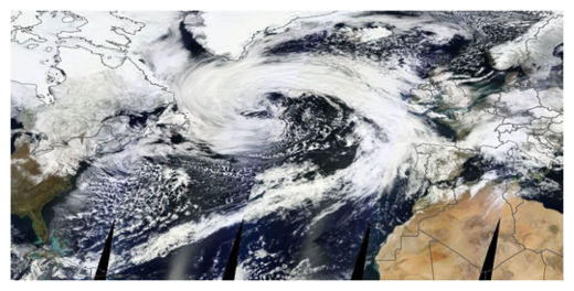
Atlantic Storm

© NASA

The storm shown here stretches west to east from Newfoundland to Portugal. Its southern tail (cold front) extends into the Caribbean and the north side of its comma head touches southern Greenland.

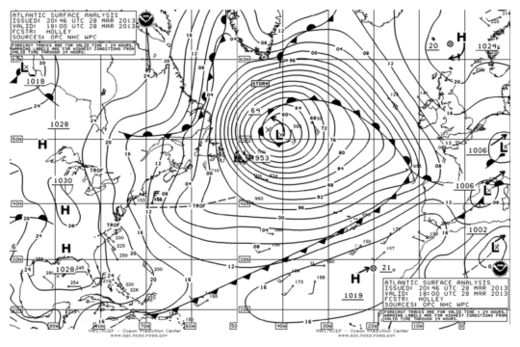
Not only is it big, but it’s also super intense – comparable to many category 3 hurricanes. The storm’s central pressure, as analyzed by the Ocean Prediction Center, is 953 mb. Estimated peak wave heights are around 25-30 feet.

Weather Map Atlantic

© Ocean Prediction Center

The storm is forecast to remain more or less stationary over the next few days before substantially weakening and then eventually drifting into western Europe in about a week as a rather ordinary weather system.

Note to Washingtonians: this is the same storm that blanketed the region with 1-4 inches of snow Monday. It’s grown into a monster from humble beginnings. The storm’s giant circulation has drawn down the cold and windy conditions we’ve had since it passed.