Not to be missed! The fifth installment in our new monthly series, the following video compiles footage of ‘signs of the times’ from around the world during May 2014 – ‘earth changes’, extreme weather and planetary upheaval.
Tag Archives: weather
SOTT Summary, February 2014: Fireballs, Extreme Weather, and Earth Changes
SOTT Summary, February 2014: Fireballs, Extreme Weather, and Earth Changes
The following video contains footage of some of the extreme weather, fireballs and seismic activity from around the world in February. Think the weather’s crazy where you live? Check out what’s happening elsewhere…
January’s ‘polar vortex’ returned to bury most of the US in snow… despite a record number of ‘winter wildfires’ breaking out as far north as Oregon.
Mount Sinabung in Indonesia erupted spectacularly… then a string of volcanoes followed the ensuing pyroclastic cloud down the mountain, while another major volcanic eruption occurred in Ecuador.
Severe flooding, tidal surges and hurricane force winds hit Western Europe, while Eastern Europe was hit by heavy snow and ice-storms.
A wildfire broke out in Wales between winter storms… as Atlanta, Georgia was knocked out by snow.
There were record snowfalls in Iran and Tokyo, more ‘strange sky sounds’ and the Great Lakes almost completely froze over.
A waterspout was filmed off the Australian coast, a major heatwave hit Brazil, and sinkholes opened up all over UK…
Is this normal?!
Senior meteorologist on extended USA cold blast to last past Groundhog day: ‘WOW F..ing WOW’
Senior meteorologist on extended USA cold blast to last past Groundhog day: ‘WOW F..ing WOW’
Normally quiet and reserved WeatherBell senior forecaster Joe D’Aleo (co-founder of the Weather Channel with John Coleman) almost never writes (email subject lines) like this. When he does, it gets my attention. A new forecast shows the cold blast in the eastern half of the USA extending well past Groundhog Day, Feb 2nd, according to their models. WeatherBell has had an excellent track record this winter so far. He says he hasn’t seen anything like it since 1918 when the big flu pandemic hit the USA.
UK weather: Environment Agency issues flood warnings for whole of England and Wales
Wow! UK and USA simultaneously! Hmmm… is there a cosmic statement there?
UK weather: Environment Agency issues flood warnings for whole of England and Wales
With the UK suffering the worst band of winter storms in more than 20 years, the Environment Agency has been forced to issue flood warnings in every single region across England and Wales.
The agency currently has around 350 alerts in place across the country as a whole, including three severe warnings which indicate there is a “danger to life”.
Last night a flood siren warning of extreme danger to people and property was sounded in Dorset, as gales and tidal surges battered the coast.
The Environment Agency raised the alarm after its sea defences were breached at Chiswell Beach in Portland last night, following on from a severe flood warning in the area.
Dorset Police told families to move to an upstairs room facing away from the sea and arm themselves with flood kits.
The Met Office said a further band of heavy showers will hit the south and southeast today, and will continue to cause a localised flooding risk throughout Tuesday and into early Wednesday.
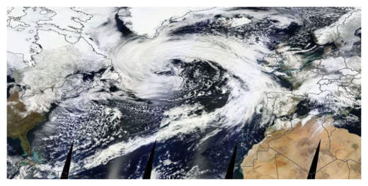
Incredible North Atlantic storm spans Atlantic Ocean, coast to coast
Global superstorms increasing. And all the elite can do is make things worse with more oppression and war-mongering. Don’t they get it that it is the collective consciousness of the unhappy masses and the ravaged planet? That they, too, will die when the body they are infecting is destroyed by their rapaciousness?
Incredible North Atlantic storm spans Atlantic Ocean, coast to coast
I’m not sure I’ve ever seen a storm this big before.
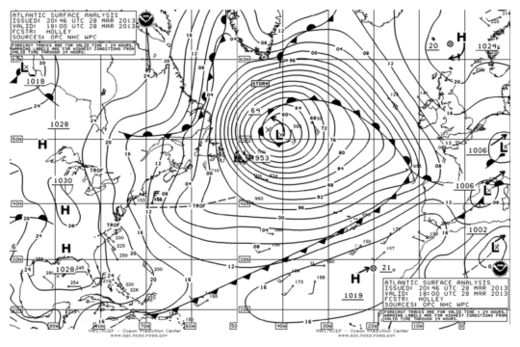
The storm shown here stretches west to east from Newfoundland to Portugal. Its southern tail (cold front) extends into the Caribbean and the north side of its comma head touches southern Greenland.
Not only is it big, but it’s also super intense – comparable to many category 3 hurricanes. The storm’s central pressure, as analyzed by the Ocean Prediction Center, is 953 mb. Estimated peak wave heights are around 25-30 feet.
The storm is forecast to remain more or less stationary over the next few days before substantially weakening and then eventually drifting into western Europe in about a week as a rather ordinary weather system.
Note to Washingtonians: this is the same storm that blanketed the region with 1-4 inches of snow Monday. It’s grown into a monster from humble beginnings. The storm’s giant circulation has drawn down the cold and windy conditions we’ve had since it passed.


